
Mapzen Exit Interview
I gave an “exit interview” to the Civicist blog, talking about the Mapzen shutdown.
The code and data were always designed to outlive the company … basically we were always working on open geo primarily, and a lot of that work feels more durable than any particular company.
The past is our burden
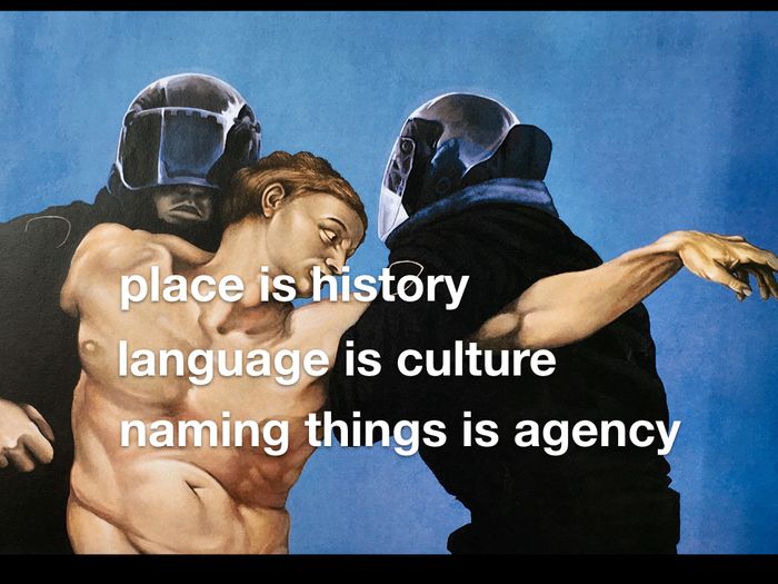
Aaron Cope on Who’s On First (which I also work on) and the responsibility that comes with naming things.
We have been blind to the fact that the First Nations were already here living on these lands long before the European settlers arrived. It is important to recognize that we have not been passive in our blindness but brutally deliberate. First out of malice and then later out of negligence and more recently out of shame.
The world is weird and wonderful!
I wrote a post over on the Mapzen blog that I think came out nicely.
The territory means different things to different people. Depending on your perspective, the kinds of data that are captured about places may be missing, insufficient, or downright hostile. Who’s On First is opinionated_—like all datasets, no collection is truly unbiased—but we hope to be aware of when we’re asserting our own opinions about places and create a framework where a polyglot of _place-feels will be welcome.
The multifaceted maps we make simply reflect the weird and wonderful territory they represent.
I’m going to be adapting this as a talk at csv,conf. If you’ll be in Portland May 3, come out and say hello. (Bring your CSVs!)
Escape from Mercator
I’ve been working with online maps since before the first Google Maps API was released, and I haven’t seen anything quite like this before. Kudos to Mapzen and Peter Richardson.
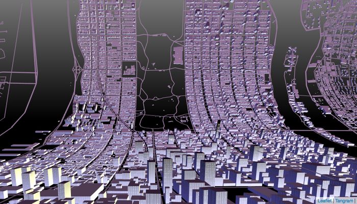
Web Mercator has been the default projection for the web since Google Maps first popularized it in 2005.
Though it is ubiquitous online (and historically useful to navigators), Mercator doesn’t get much love from the modern cartographer. And in general, Mercators are unsuited for cases when you want to compare the size or shape of anything that isn’t near the equator. So while Web Mercator is useful, we’ve been using Tangram to explore other options.
Tangram draws maps in real-time in your web browser, using a hotline to your graphics card called OpenGL.